US Army Corps of Engineers
Coastal Inlets Research Program-
 Home
Home
-
 Products
- CMS
- ----------------------
- AISAP
- Aeolian Processes
- CIRP Map Portal
- CPT
- CSAT
- Depth of Closure
- FUNWAVE
- GenCade
- Inlet Engineering Tools
- Nearshore Nourishment Hub
- Sand Snap
- Satellite Shoreline Mapper
- Sediment Budget Analysis System
- Sediment Mobility Tool
- SMS
- WIS Portal Wave Tool (formerly WaveNet)
- ----------------------
- All CIRP Products
- Navigation Portal
-
 Publications
-
 Tech Transfer
- CIRP Tech Discussions
- Webinars
- 18 November 2020 - GenCade/SBAS Demonstration
- ----------------------
- 16-20 September 2019 - CMS Advanced Topics with SMS 13.0
- 06-10 May 2019 - CMS Basics with SMS 13.0
- 19-22 April 2016 - WaveNet and TideNet
- 04 December 2013 - PTM with CMS Webinar
- 25 July 2013 - Sediment Budget Calculator
- 11-15 June 2012 - Coastal Modeling System Basics
- 18-22 June 2012 - Advanced CMS
- 16-18 October 2012 - GenCade
- Workshops
- Meetings
- ----------------------
- CHL Navigation R&D Collaboration Video
- Brochures
- Posters
- Recent Advancements in the CMS
- Navigation Portfolio Metric Derived from AIS Vessel Traffic Data
- Tools to Investigate Erosion due to Vessel Operations
- Tools for Simulating Aeolian Sediment Transport Near Inlets
- ----------------------
- Modified Bruun Rule
- Automated Extraction of Foredune Morphology from Lidar Data
- Quantification of Dune Response during Nor'easter, Outer Banks, NC
- Long-term Morphology Modeling of Barrier Island Tidal Inlets - ECM14 2016
- Sediment Mobility Tool - RARG 2016
-
 Wiki
Wiki
-
 CIRP
CIRP
-

US Depth of Closure Information

Depth of closure (DOC) is an important concept used in coastal engineering. The DOC is a theoretical depth along a beach profile where sediment transport is very small or non-existent, dependent on wave height and period, and occasionally, sediment grain size. More specifically, Kraus (1998) states that the “depth of closure for a given or characteristic time interval is the most landward depth seaward of which there is no significant change in bottom elevation and no significant net sediment transport between the nearshore and the offshore.” Often the DOC is used in coastal engineering design for projects such as beach and nearshore berm nourishments, and jetty and navigation channel designs. The dataset provided here estimates DOCs for all of the coast lines of the United States, including the Great Lakes, using the USACE Wave Information Study (WIS) wave hindcast data. A few related publications including a technical note detailing methods used to produce the dataset are provided as well.
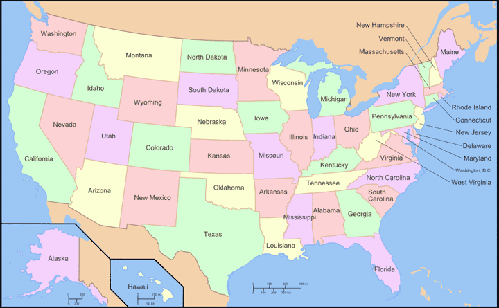
Click an area below for the Depth of Closure data by region |
|---|
|
Note: For all IE users, compatibility mode must be OFF for the image links to work.
For instructions, click here.
Links to files: |
|
|---|---|
Gulf of Mexico Region
|
Pacific Region (including Hawaii)
|
Great Lakes Region
|
Atlantic Region
|
Alaska Region
|
|
Documentation
Point of Contact
