US Army Corps of Engineers
Coastal Inlets Research Program-
 Home
Home
-
 Products
- CMS
- ----------------------
- AISAP
- Aeolian Processes
- CIRP Map Portal
- Coastal Nav. Portfolio Mgmt
- CPT
- CSAT
- Depth of Closure
- FUNWAVE
- GenCade
- Inlet Engineering Tools
- Nearshore Nourishment Hub
- Sand Snap
- Satellite Shoreline Mapper
- Sediment Budget Analysis System
- Sediment Mobility Tool
- SMS
- WIS Portal Wave Tool (formerly WaveNet)
- ----------------------
- All CIRP Products
- Navigation Portal
-
 Publications
-
 Tech Transfer
- CIRP Tech Discussions
- Webinars
- 08/07/24 - 08/02/24 - GenCade with SMS 13.3
- 07/29/24 - 08/02/24 - CMS Basics with SMS 13.3
- ----------------------
- 11/18/20 - GenCade/SBAS Demonstration
- 16-20 Sep 2019 - CMS Advanced Topics with SMS 13.0
- 06-10 May 2019 - CMS Basics with SMS 13.0
- 19-22 Apr 2016 - WaveNet and TideNet
- 04 Dec 2013 - PTM with CMS Webinar
- 25 Jul 2013 - Sediment Budget Calculator
- 11-15 Jun 2012 - Coastal Modeling System Basics
- 18-22 Jun 2012 - Advanced CMS
- 16-18 Oct 2012 - GenCade
-
Workshops
- 2026 Norfolk - CMS/GenCade Workshop
- ----------------------
- 2024 Buffalo - CMS/GenCade Workshop
- 2023 Los Angeles - CMS/GenCade Workshop
- 2022 Mobile - CMS/GenCade Workshop
- So you think you got a shoal? Workshop
- Automatic Identification System (AIS) Technical Workshop
- 2018 Detroit - CMS/GenCade/PTM Workshop
- All Workshops
- Meetings
- ----------------------
- CHL Navigation R&D Collaboration Video
- Brochures
- Posters
- Recent Advancements in the CMS
- Navigation Portfolio Metric Derived from AIS Vessel Traffic Data
- Tools to Investigate Erosion due to Vessel Operations
- Tools for Simulating Aeolian Sediment Transport Near Inlets
- ----------------------
- Modified Bruun Rule
- Automated Extraction of Foredune Morphology from Lidar Data
- Quantification of Dune Response during Nor'easter, Outer Banks, NC
- Long-term Morphology Modeling of Barrier Island Tidal Inlets - ECM14 2016
- Sediment Mobility Tool - RARG 2016
-
 Wiki
Wiki
-
 CIRP
CIRP
-

PC-Based Products and Tool Archive
Click an option below to obtain additional information
Note: Most of these tools were designed for Windows XP or earlier operating systems and are no longer actively supported.
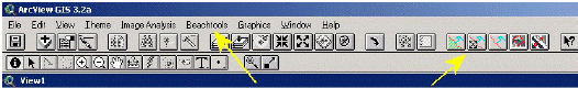
Two ArcView/ArcGISTM extensions are available that are designed to identify and quantitatively establish the position of the shoreline and other coastal features from aerial imagery - one for ArcViewTM 3.2 and one for ArcGISTM 9.1. Please choose the correct plugin from the choices below.
- BeachTools ArcView 3.2 Plugin. - [ 660kb AVX file ] - PDF
- BeachTools ArcGIS 9.1 Plugin. - [ 268kb DLL file ]
- PDF (May or may not work with ArcGIS 9.2/9.3 - the next update will address this issue)
Hold down the shift key and click on the above link to download the appropriate BeachTools Plugin for your system.
Aerial imagery, i.e., digitized aerial photography, is commonly analyzed to qualitatively and quantitatively study the evolution of coastal inlet geomorphology. BeachTools is designed to facilitate such studies by providing a suite of tools that allows for the automatic delineation of coastal features and the generation of baselines and transects, removing the tedium and subjectivity of extracting data by hand, and allowing for much greater precision of such measurements.
Documentation is available from the PDF link next to each plugin listed above.
Visit this page for more information
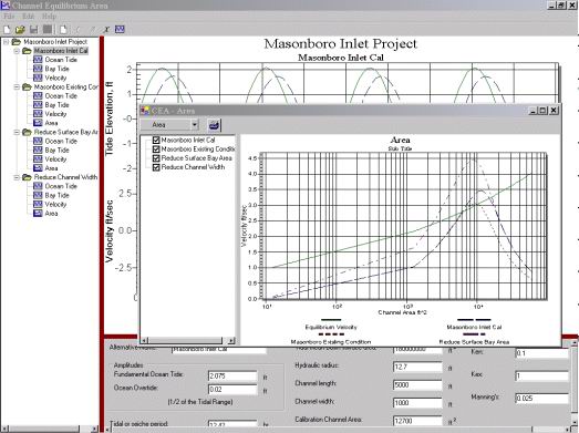
CEA is a standalone PC program for the Windows operating system. Download the Zip-compressed archive for this program by holding down the Shift-key and clicking on the link below.
Download CEA Program zip archive -- 26 Mbyte download.
Installation of CEA: -- Place zip archive in directory of your choosing and unzip the archive. First install the .NET framework by double-clicking on the file dotnetfx.exe. Then you will be able to install CEA by double-clicking on the file setup.exe
The Coastal Engineering Design and Analysis System (CEDAS) is a comprehensive collection of coastal engineering design and analysis software, developed by or for the U.S. Army Engineer Waterways Experiment Station. CEDAS is interactive system for Windows 95/98/2000 or NT-based PCs. The system contents range from the simple technologies of the popular ACES package, to sophisticated models for multi-dimensional hydrodynamics, wave propagation, nearshore hydrodynamics and beach processes, inlet technology, and harbor oscillation. Additional information is available at the Veri-Tech web site.
Visit this page for more information
Hold down the shift key and click on the above link to download the Ebb Jet Calculator!
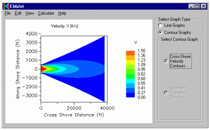
The EbbJet Calculator allows quick estimation of the ebb or flood jet issuing from an inlet based on the analytical solution of flow from Ozsoy and Unluata (1982). Estimates of sediment transport are developed from the sediment transport equations published by van Rijn (1984a, 1984b, and 1984c). Developed for inclusion in the Diagnostic Modeling System Analytical Toolbox, the EbbJet Calculator provides estimates of flow velocity and associated sediment transport at inlets that can aid in optimizing channel location and estimation of shoaling rates.
Further details are given in this Technical Note.
![]() HyPAS: The Hydraulic Processes Analysis System (HyPAS) is a tool designed to manipulate and view large data sets of high resolution
hydrodynamic data such as three-dimensional currents collected with Acoustic Doppler Current Profilers (ADCP).
HyPAS: The Hydraulic Processes Analysis System (HyPAS) is a tool designed to manipulate and view large data sets of high resolution
hydrodynamic data such as three-dimensional currents collected with Acoustic Doppler Current Profilers (ADCP).
Impacts of Inlets on Adjacent Beaches
Please copy all these files into a new folder on your PC. Then double-click the IIAB Standalone Java Program and populate fields with each file as directed, or modify for your site-specific data. To copy the data to an excel spreadsheet and manipulate plots, you can paste into the attached "Application Workbook".
Download IIAB Files -- (1 zip file containing these files) - Updated 17 May 2012
- IIAB Standalone Java Program
- Example Ebb and Flood Shoal Data
- Example Shoreline Data
- Example O&M Dredging Data
- Application Workbook (Excel 2007 file)
NOTE: Units in this example are in Meters.
Also, for information on the IIAB, go to “Help-App Instructions” from within the Java Program.
IIAB Documentation can be found on the CIRP wiki:
http://cirpwiki.info/wiki/IIAB/Overview
Point of Contact:
- Julie Rosati
Email: Julie.D.Rosati@usace.army.mil
Engineer Research and Development Center
3909 Halls Ferry Road
Vicksburg, MS 39180
Hold down the shift key and click on the above link to download the InletGIS Plugin!
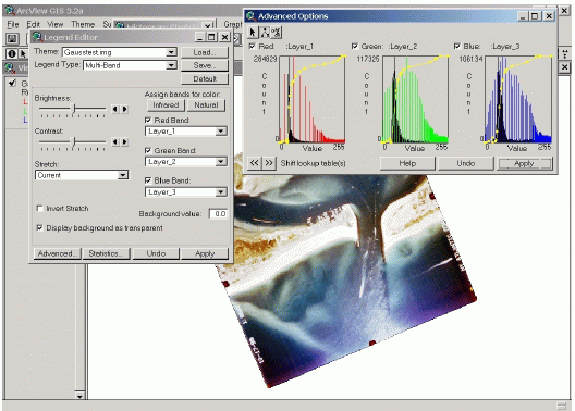
Further details are given in this Technical Note.
![]() Inlets Online: An online information and analysis resource on tidal inlets, navigation
channels, and adjacent beaches. It is intended to serve as a tutorial for nonspecialists and an information
center for specialists in fields related to coastal inlets.
Inlets Online: An online information and analysis resource on tidal inlets, navigation
channels, and adjacent beaches. It is intended to serve as a tutorial for nonspecialists and an information
center for specialists in fields related to coastal inlets.
Regional Morphology Analysis Package (RMAP)
RMAP (Regional Morphology Analysis Package) - an integrated set of calculation tools developed for manipulating, analyzing, visualizing, and archiving data on shoreline positions and beach profiles in a georeferenced environment on a personal computer. RMAP supports analysis of beach profile, channel or river cross-sectional data, and shoreline position data for engineering and science applications. Capabilities extend from generation of spatially referenced shoreline change maps to a large suite of beach profile analysis tools.
RMAP is sponsored by the Coastal Inlets Research Program (CIRP).
Latest Version:
- RMAP 3.2 PC Program [~128 MB installation executable] - updated February 2012
Note: Uninstall previous versions before installing this version.
Tutorial files can be downloaded here.
Publications:
CHETN
- Regional Morphology Analysis Package (RMAP), Version 3: User's Guide and Tutorial
Application:
RMAP Demonstration Project for the New Jersey Coast
Engineer Research and Development Center
3909 Halls Ferry Road
Vicksburg, MS 39180