US Army Corps of Engineers
Coastal Inlets Research Program-
 Home
Home
-
 Products
- CMS
- ----------------------
- AISAP
- Aeolian Processes
- CIRP Map Portal
- CPT
- CSAT
- Depth of Closure
- FUNWAVE
- GenCade
- Inlet Engineering Tools
- Nearshore Nourishment Hub
- Sand Snap
- Satellite Shoreline Mapper
- Sediment Budget Analysis System
- Sediment Mobility Tool
- SMS
- WIS Portal Wave Tool (formerly WaveNet)
- ----------------------
- All CIRP Products
- Navigation Portal
-
 Publications
-
 Tech Transfer
- CIRP Tech Discussions
- Webinars
- 18 November 2020 - GenCade/SBAS Demonstration
- ----------------------
- 16-20 September 2019 - CMS Advanced Topics with SMS 13.0
- 06-10 May 2019 - CMS Basics with SMS 13.0
- 19-22 April 2016 - WaveNet and TideNet
- 04 December 2013 - PTM with CMS Webinar
- 25 July 2013 - Sediment Budget Calculator
- 11-15 June 2012 - Coastal Modeling System Basics
- 18-22 June 2012 - Advanced CMS
- 16-18 October 2012 - GenCade
- Workshops
- Meetings
- ----------------------
- CHL Navigation R&D Collaboration Video
- Brochures
- Posters
- Recent Advancements in the CMS
- Navigation Portfolio Metric Derived from AIS Vessel Traffic Data
- Tools to Investigate Erosion due to Vessel Operations
- Tools for Simulating Aeolian Sediment Transport Near Inlets
- ----------------------
- Modified Bruun Rule
- Automated Extraction of Foredune Morphology from Lidar Data
- Quantification of Dune Response during Nor'easter, Outer Banks, NC
- Long-term Morphology Modeling of Barrier Island Tidal Inlets - ECM14 2016
- Sediment Mobility Tool - RARG 2016
-
 Wiki
Wiki
-
 CIRP
CIRP
-

Satellite Shoreline Mapper (SSM)
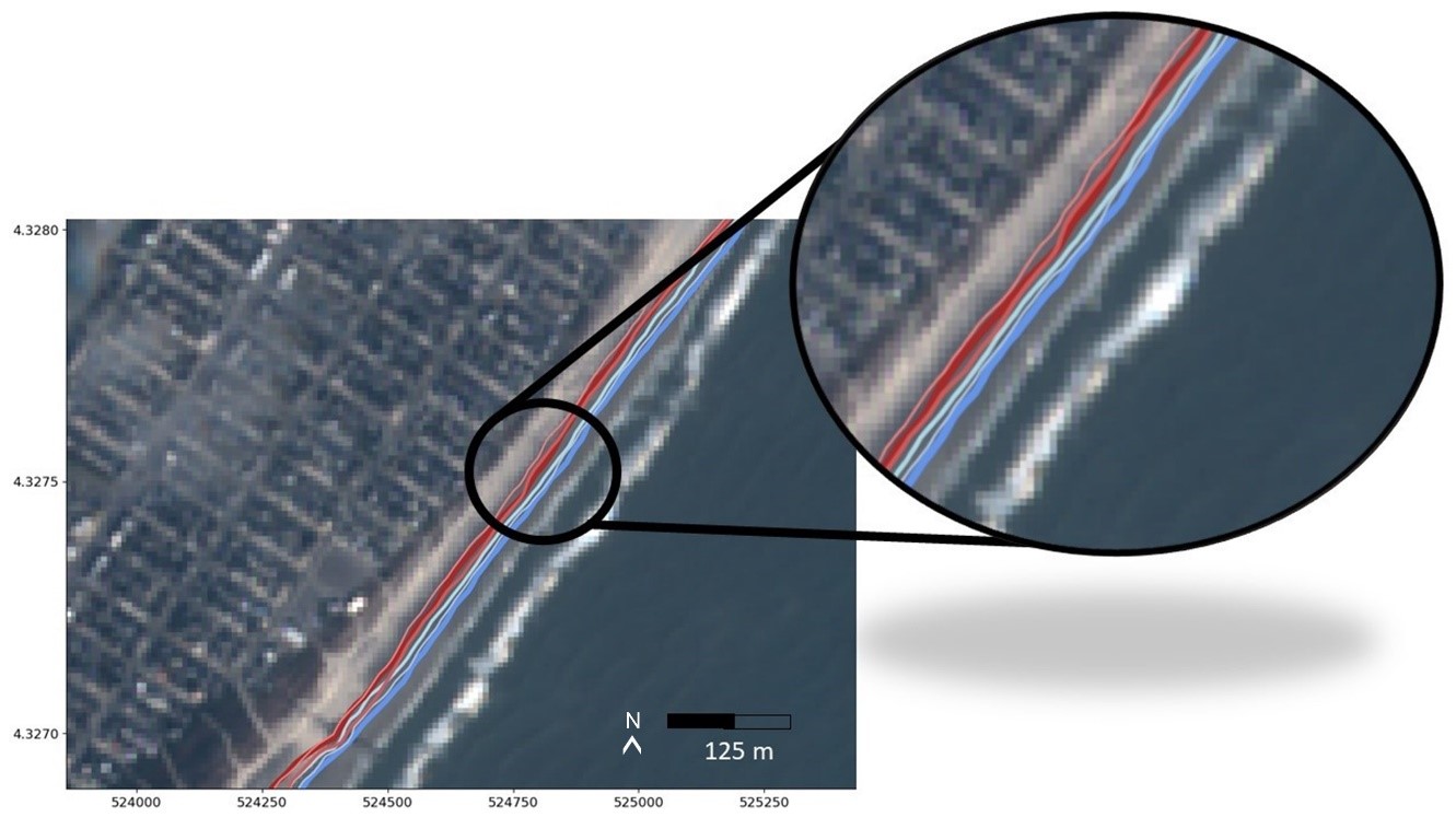 The ERDC Satellite Shoreline Mapper is a user-friendly ArcGIS tool that automatically extracts historic shorelines along sandy coastlines from publicly available satellite imagery dating back to 1984 (Landsat missions and Sentinel-2). The tool was created using the open-source CoastSat algorithm, developed by Vos et al. (2019, J. Coastal Eng.) at the University of New South Wales (UNSW). The user specifies an AOI and time interval, along with a few other parameters (i.e., transect spacing, contour, slope, folder location), then Google Earth Engine ingests imagery every 5 to 16 days, image pre-processing is conducted, imagery is classified and the Modified Normalized Difference Water Index (MNDWI), Otsu’s thresholding method and machine learning are employed to automatically extract the shoreline position along the transect, resulting in a shoreline time series and other analysis products. CoastSat and the SSM tool are capable of calculating beach slope as well if it is unknown at the site. Lastly, a tidal correction is performed based on the time of image acquisition. This tool is co-sponsored by the Coastal Inlets Research Program (CIRP) and the Coastal Ocean Data Systems (CODS) program.
Benefits: SSM is expected to provide USACE Districts access to a new data source, enabling wide-spread frequent coastal data with low cost and personnel commitment. SSM adds the ability to examine shoreline variability (short and long term), “now state” of coastline and help with preliminary planning, project design and monitoring for districts managing beach projects and storm impacts.
Applications: SSM can be used for short- and long-term monitoring and analysis of sandy coastlines. Researchers have validated the algorithm at test sites around the world using long-term ground truth datasets for comparison (e.g., Vos et al., 2023; Duck, NC; Narabeen, AU; Truc Vert, FR, Torrey Pines, CA). ERDC researchers have tested and validated SSM at many U.S. sites encompassing a range of coastal characteristics and engineering projects, some of which include Duck, NC (nourishments), Benson Beach, WA, Torrey Pines, CA, Cardiff, CA, Imperial Beach, CA, South Padre Island, TX (nourishments), Galveston, TX (nourishments), Avalon, NJ (nourishments), Lake Michigan, Indiana Dunes State Park, New Smyrna Beach, FL (nearshore berm placement), and Harvey Cedars, NJ (nearshore berm placement).
Required Software:
- Anaconda
- The version of Anaconda should not matter. Check to see if you have it already by searching for “Anaconda” from the start menu. If not, install:
- ACE-IT users: Go to the App Portal and Install 'Anaconda Anaconda3 2022.05'
- Other users: Anaconda - https://www.anaconda.com/download
-
Google Earth Engine (GEE)
-
CoastSat downloads imagery through Google Earth Engine which requires users to register at
https://signup.earthengine.google.com
-
CoastSat downloads imagery through Google Earth Engine which requires users to register at
- ArgGIS Pro (tested with both v3.0 and v3.1)
Installation Instructions:
- Complete installation instructions can be found here: User Manual (PDF)
- Required tool files can be downloaded here: SSM Tool (zip file)
| Related Publications | |
|---|---|
| ERDC Satellite Shoreline Mapper, Version 1.0 | Presentation |
| Quantifying Coastal Evolution and Project Performance at Beaches Using Satellite Imagery | Technical Report (draft) |
Points of Contact
