US Army Corps of Engineers
Coastal Inlets Research Program-
 Home
Home
-
 Products
- CMS
- ----------------------
- AISAP
- Aeolian Processes
- CIRP Map Portal
- CPT
- CSAT
- Depth of Closure
- FUNWAVE
- GenCade
- Inlet Engineering Tools
- Nearshore Nourishment Hub
- Sand Snap
- Satellite Shoreline Mapper
- Sediment Budget Analysis System
- Sediment Mobility Tool
- SMS
- WIS Portal Wave Tool (formerly WaveNet)
- ----------------------
- All CIRP Products
- Navigation Portal
-
 Publications
-
 Tech Transfer
- CIRP Tech Discussions
- Webinars
- 18 November 2020 - GenCade/SBAS Demonstration
- ----------------------
- 16-20 September 2019 - CMS Advanced Topics with SMS 13.0
- 06-10 May 2019 - CMS Basics with SMS 13.0
- 19-22 April 2016 - WaveNet and TideNet
- 04 December 2013 - PTM with CMS Webinar
- 25 July 2013 - Sediment Budget Calculator
- 11-15 June 2012 - Coastal Modeling System Basics
- 18-22 June 2012 - Advanced CMS
- 16-18 October 2012 - GenCade
- Workshops
- Meetings
- ----------------------
- CHL Navigation R&D Collaboration Video
- Brochures
- Posters
- Recent Advancements in the CMS
- Navigation Portfolio Metric Derived from AIS Vessel Traffic Data
- Tools to Investigate Erosion due to Vessel Operations
- Tools for Simulating Aeolian Sediment Transport Near Inlets
- ----------------------
- Modified Bruun Rule
- Automated Extraction of Foredune Morphology from Lidar Data
- Quantification of Dune Response during Nor'easter, Outer Banks, NC
- Long-term Morphology Modeling of Barrier Island Tidal Inlets - ECM14 2016
- Sediment Mobility Tool - RARG 2016
-
 Wiki
Wiki
-
 CIRP
CIRP
-

Recent Technical Discussion
What's New
Special Report - Coastal Modeling System User's Manual
This special report acts as a user guide for the CMS, which contains comprehensive information on model theory, model setup, and model features. The detailed descriptions include creation of a new project, configuration of model grid, various types of boundary conditions, representation of coastal structures, numerical methods, and coupled simulations of waves, hydrodynamics, and sediment transport.
Click here to access full report.
CSAT version updated to v2.6.3 (25 Jan 2024)
Our installation has changed to allow for newer versions of Anaconda/Python and account for prior Anaconda versions being removed.
Other changes listed on the web page.
Let us know if you experience any issues.
The Coastal Inlets Research Program (CIRP)
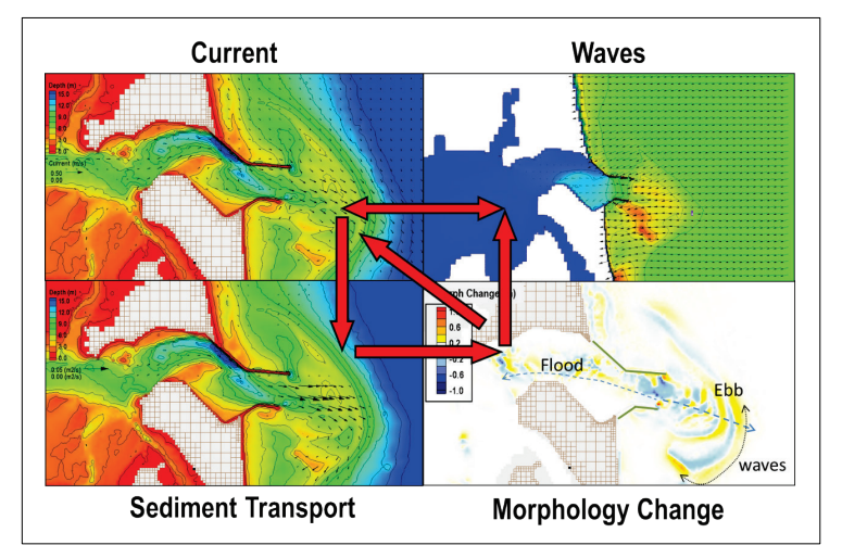
Because of the multiple interacting forces and the numerous scales of geomorphic change ranging in time from days of a storm to centuries for long-term adjustment, the physical processes of inlets are poorly understood. Little quantitative information is available to predict infilling of navigation channels, long-term change in the nearshore – affecting channel and jetty stability, short- and long-term migration trends and cycles of inlets, and the interactions among inlets, adjacent beaches, and estuary.
The Coastal Inlets Research Program, or CIRP, advances the state of knowledge and develops engineering technology for predicting the waves, current, sediment transport, and morphology change at and around inlets. Products of the CIRP improve management and design of coastal inlets through increased reliability of actions and reduction in operation and maintenance costs. The CIRP takes a variety of approaches, including developing concepts and theory for all relevant time scales, numerical simulation, field data collection, and laboratory experimentation. Reports and peer-reviewed articles as found on this web site provide the information gained from the CIRP to the Corps, scientific community, and public.
Point of Contact

Recent Updates
Introductory video on the Coastal Inlets Research Program from ERDC Corporate Communications.
CSAT Analyses of High-density Bathymetry: Shoaling along a section of the lower Mississippi River using USACE eHydro datasets collected for the entire calendar year 2019.
More Information