US Army Corps of Engineers
Coastal Inlets Research ProgramDune Response Tool (DRT)
The Dune Response Tool (DRT) helps apply morphologic changes to dune systems through a straightforward graphical user interface. The model was developed to be easy to use, run on a standard laptop computer, and provide fast simulation times. The tool uses existing public web-based environmental and morphology datasets across much of the United States coastline and the primary usage for this tool is dune morphology predictions and calculations from two primary forcing sources:
- Dune retreat due to high water levels during storm events
- Dune growth due to wind-based (aeolian) sediment transport
For erosional purposes, the model assumes dune scarp principles from Palmsten and Holman (2012, see publication below), assuming that a direct relationship between erosion and impact forces on the dune face exist. For recovery purposes, dune vegetation and topographic details are the primary factors. The tool calculates only the overall volumetric sediment inputs into the dune system due to wind and spatial distribution of the sediments accreted are not directly modeled.
In depth details and specific model drivers can be further read within the 2022 USACE Technical Note, listed in publications below. The DRT is downloaded from the ERDC GitHub and contains instructions to install the model as a MATLAB graphical user interface (GUI). Figure 1 below shows the GUI used to set model parameters and run the DRT. User inputs to the model include location information (lat/long), morphology information (either input manually or pulled from various database files based on the latitude and longitude provided), and timing (allowing for hindcasting or forecasting). Advanced model parameters such as grain size and wave runup information can also easily be modified by the user.
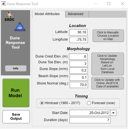
Figure 1. Dune Response Tool Graphical User Interface with example data
Once run, the DRT produces a figure with the input environmental timeseries, initial and final dune profiles, and dune volume change in erosion and accretion. An example output from the simulation run in the TN provided below is shown below in Figure 2. This example is for a New Jersey shoreline during Hurricane Sandy and includes the dune toe elevation of 1.8 meters NAVD88 and a dune crest elevation of 2.9 meters NAVD88. Further discussion of this example can be found in Cohn and Brodie (2022).
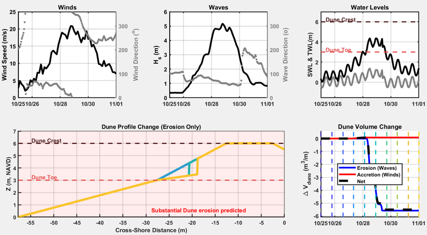
Figure 2. Environmental time series, erosional profile changes, and calculated volume changes from a new Jersey beach during Hurricane Sandy.
| Related Publications | |
|---|---|
| 2022 Technical Note | In progress |
| Laboratory investigation of dune erosion using stereo video | Coastal Engineering, Feb 2012 |
| Meso-scale modelling of aeolian sediment input to coastal dunes | Geomorphology, Jul 2011 |
| Study on Sand Movement by Wind | Kawamura, 1951 |