US Army Corps of Engineers
Coastal Inlets Research ProgramMarsh Transect Model (MTM)
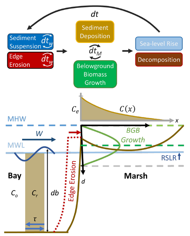
DESCRIPTION: The Marsh Transect Model (MTM) is a one-dimensional numerical model that simulates wave-induced marsh edge erosion, marsh elevation change due to below-ground mineral and organic material, and wetland migration over decadal timescales. The code is a variation of the Bay-Marsh-Forest Transect Carbon Model (BMFTCM) [Kirwan et al. 2016] and includes temporally explicit wind or wave forcing inputs, non-uniform forcing time-steps, non-uniform cell sizes, and a wider range of conditions. The model is written in MATLAB™, a commercially available software package designed for high-performance data analysis, model building, and visualization. A Windows™-based executable file has been developed for users that do not have access to MATLAB™.
BENEFITS: The MTM is flexible, allowing users to define their own input parameters to meet project specifications. Typical runtimes are seconds to minutes, thus allowing users to explore a wide variety of alternatives in a short period of time. This rapid screening feature gives planners and managers the flexibility to explore many wetland evolution scenarios, including sea level rise, and quantify model uncertainty.
APPLICATION: Planners and engineers can use the MTM to determine (1) if the selected location is viable for the continued persistence of a coastal marsh, (2) what (if any) structures may be required to maintain the coastal marsh, (3) the capacity of the marsh to reduce erosion and attenuate waves and/or storm surge in the future, and (4) the maintenance requirements to achieve required coastal marsh geometry models.
This FY22 work is co-sponsored by DOER and CIRP. 

| Publications | |
|---|---|
| Instruction Manual | October 2021 |
| Technical Note (DRAFT) | In Progress |
| Sea Level Driven Marsh Expansion in a Coupled Model of Marsh Erosion and Migration. | Kirwan et al 2016 |
| Executable |
|---|
| Marsh Transect Model |